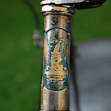
I'd like to tell the whole story of Bones covering all of his 50 or 60 odd years of bikeness, but I only know his history from when Jen and Donn collected him, in un-ridable condition from the, Green Bike Trust. Until early 2007, he was ridden mostly by Jen but sometimes by Donn.
 And then there was an incident involving Jen's toes and the front wheel. It was pretty bad. The toes needed stitches and the front wheel lost a couple of spokes.
 After that Bones sat around not really doing anything for almost a year until I had a couple of spare days of the christmas break. After replacing the broken spokes, there wasn't much more I could do for the wheels apart from scrape off the worst of the rust.
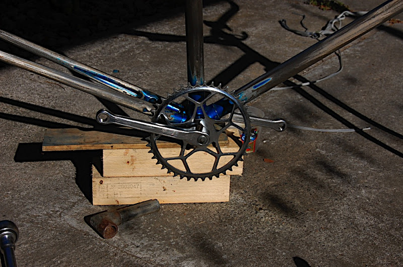
 The rest of the bike I stripped (even successfully removing the cottered cranks --- previously a source of problems --- using a new hammer and Sheldon Brown's excellent guide) and sanded, with help from N. The shiny steel and the effect of streaks of old paint seemed too nice to cover up so Bones got a few coats of clear gloss and a grease before he was rebuilt. The result is pretty smart looking if I do say so myself. The frame is a little small for me, especially with the short seat-post, so he gives me a bit of knee pain going up hills, but with bikes, sometimes you have to suffer for your fashion.


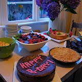
Happy birthday (for Friday) Aurelie!

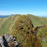
In keeping with the New Spirit of Frugality with which the country/western-world seems awash at the moment, N. and I stayed close to home for summer adventures this year. We planned a nine day tour of the Tararua ranges. Then, as we looked at the growing mountains of pre-packaged couscous and dried tomato we would take, an eight day tour (the same tour in fact, just faster). Here's some sort of overview of the trip. A dull and terse, day-by-day description of our route and times and whether it was raining or not. Pictures from the dryer moments of the trip are o'er at Picasa too:
26/12, Day one: Tamsin and Lorraine dropped us at the end of Waiohine Valley road about 10 am. No sign of shade at all as we sweated our way across the farmland towards the bush edge. Despite taking NSoF meals of couscous and dried tomatoes (250gms for two) instead of curry pouches and dehy. potatoes (590gm for two), my pack was 30kg, N.'s was 20. We were slow. The track over Mt Reeves to Tutawai hut was posted as four hours. We did 3h40 to the top of Reeves and then 1h10 for the rest of the way (downhill and in the shade) to the hut. From there we followed the Tauherenikau river north to Cone hut (1h10 for us, posted time 1hr). I arrived in no doubt that the Pain of Indeterminate Cause which had plagued my ankle earlier in the month on a walk over the Rimutakas was back and prevented me wearing my tramping boots in their current state. An hour or cutting pieces out of the side of my boot with a knife left me with a pile of foam, gor-tex and leather pieces and the realisation that the PoIC was not going away as long as I was wearing boots. Shoes with a top below my ankle were fine. The idea of wearing some light running shoes, which were packed to use as hut slippers, for a week long trip in the the mountains didn't seem like the right thing. Still, I didn't want to have to walk out after just one day...

 27/12, Day two: A slow start after bagels for breakfast. The track was all in the shade so N. was happier. My tramping boot substitutes were a bit slippery but the PoIC showed no signs of returning so we decided we wouldn't either. Not just yet. My pack seemed heavier. My pack was heavier! In a moment of foolishness I decided to pack out the empty fuel canisters which some kind soul had left at the hut, just in case. 45 minutes to Cone Saddle, 2h up to cone peak where the sun turned to blustery rain and mist as soon as we cleared the bush line. Out with the compass to make sure we didn't end up on the Neill-Winchcomb track and then 2h10 down cone ridge to the Neill Forks/Totara Flats junction. The sun returned the moment we were back below the bushline. N. was happy enough with this --- she really doesn't like bright sun --- I wouldn't have minded a view from the top of Cone. 1h25 more to Neill Forks hut. Another night with a hut to ourselves, not even a sandfly about to disturb our NPoF couscous.

 28/12, Day three: A short route for today, but uphill all the way. About 3h to Concertina Knob, 1h more to the top of Maungahuka and the 10 minutes further to Maungahuka hut in time for lunch and views of the Tararua peaks as the sky cleared. We had views of the Wairarapa towns and of Otaki. With views go cellphone coverage, with cellphone coverage goes an update in the weather report if you get lucky. Fine tomorrow, winds changing to NW in the evening, rising the next day. Gales for the day after that.
We left our packs in the hut and made a side trip to the Tararua peaks to see what all the fuss was about. No problems skirting around Tunui and taking the 20m steel ladder up the side of Tuiti without packs, wind, snow, rain, etc. But I get the point that one might want to avoid the peaks in less favourable weather. Great views of, well ev erything from the top of Tuiti: Kapiti island, Farewell Spit, the Marlborough Sounds and Kaikoura ranges. No clouds in the other direction either. And a hut to ourselves again.


 29/12, Day four: Moderately desperate times call for moderately desperate measures. We managed to be walking by 8 am and hoped to get ahead by a hut or two to try and be down from the tops when the gale was forecast to arrive. Brilliant sun and not a breath of wind made it hot going. It pretty much made it not the Tararuas. Or did the mountains know that N. would find a day in the glaring sun worse than any (well at least many) storms? We carried 5.5 L of water between us and by rationing it carefully we didn't run out until we were almost at Anderson Memorial hut 5h30 later. The posted time was 6h but N. fair ran up the hills when it was clear there wasn't going to be any shade before the hut. We saw a giant worn too, around 40cm long!
After a rather-long-but-far-too-short lunch break we continued north. The track to Junction peak was posted 30min but we stretched this to a hot and grumpy 1h25, the further 1h30 posted to Nichols hut became 2h15 for us --- though that was perhaps due to the time I spent taking photos of the Easter ridge of Holdsworth, the Broken Axe Pinnecals, Angle Knob, etc. It was dinner time when we reached Nicolas hut. The weather had changed, going from clear skies to blustry NW rain in about 20 minutes. Dracophylum biv was posted as 3h further along with the track mostly under cover. We thought we'd push for it. 4h later we reached the biv at close to 11pm. We'd scrambled hands and feet down the last rocky knob in the last of the daylight with wind and rain making holds slippery. The last couple of hours walking seemed to last forever. We had a tent but the ridge barely had enough flat space to sit so short of wrapping the tent fly around us and waiting for the light it was push on to the biv. Thankfully we had this one to ourselves too. A 14 hour day, even if the posted track times only added up to 11, but it brought the eight day trip down to seven days.


 30/12, Day five: Gales were still forecast for the following day so we were keen to get off the tops while we still could. Mist and rain meant we didn't get any views between Dracophyllum biv and the new Areta biv where we stopped for lunch after 4h10. We met a party of four about Butcher Knob who had spent the night at Arete and were heading to Dracophyllum biv since they thought the weather was too bad to go down via Pinnacle Spur. We were heading for Pinnacle Spur because we thought the weather was too bad to do anything else. The wind and rain on the approach to Arete made for tough going and a compass was necessary to make sure we followed the correct one of the five ridges that lead off Arete in all directions. The weather after lunch was worse, mostly due to the strength of the wind which made it difficult to stand. I've never used a walking pole for staying upright in the wind before. The visibility was only about ten metres so we moved pretty slowly with frequent stops to check the compass. This didn't prevent us from taking the wrong ridge almost to the top of Mt Lancaster. We were saved by a brief clearing in the clouds which allowed us to see the Waiohine Pinnacles to the east of us and the metal stake marking the top of Pinnacle Spur. We backtracked and descended the spur by hanging off bits of tussock and leatherwood. Once off the ridge the visibility improved with the clouds sitting above our heads. The wind gusts made for some exciting moments climbing over some of the rocky knobs on the way down the spur. Once the spur entered the bush the cut track was steep and muddy. Not enough trampers had been through to clear the beech leaves from the track which made things extra slippery. We took about 4h45 down Pinnacle Spur to Arete Forks hut --- another night with a hut to ourselves and, this time, a fire to dry some wet clothes.


 31/12, Day six: It might have been a gale in the tops, (the clouds did move over our heads very quickly), but down in the Waingawa valley the weather was good. The hard bits were over and all we had to do was make it back to the road end now. After a 12pm start we had an easy 4h50 walk to Cow Creek hut. For the first time on the trip there were other people in the hut; four of them in a six bunk hut. We'd carried a tent all this time and there was a perfect camping spot near the Waingawa river so we did the private thing. Three more people turned up shortly after so we knew we'd done the right thing. We chilled our tiny bottle of bubbly in the river and preemptively celebrated the new year about eight o'clock then crawled into the tent to listen to the wind and rain.


 1/1, Day seven: Happy New Year to us! Things were still a bit gusty but the rain had stopped before we woke up. We crossed the enormous new swing bridge which has replaced the cableway across the Waingawa. After a bit of muddling about crossing a slip we found the cut track and climbed up to the Blue Range hut junction (3h20) then strolled down to the Kiriwhakapapa road end with the track getting progressively wider and wider as we got closer to the carpark 1h10 further on.
Walking back into civilisation was a bit of a strange feeling. The most people we'd seen until then was the day we meet two parties at Cow Creek hut so coming across large numbers of people in the picnic area and making five minute strolls along the track was a change from the previous week. Lorraine and Tamsin met us at the road end with cold beer. The perfect finish to an enjoyable tour. Next goal: visit all the huts in the Tararuas before the end of the year.