
30 January, 2011
Jumbo-Holdsworth Trail Race
As part of (i.e. pretty much all of) my training for the Tararua Mountain race (now postponed until next summer), I ran the Jumbo-Holdsworth Trail Race. The race is about 26km and goes from Holsdworth Lodge along the Atiwhakatu track to Rain-gauge spur, where it climbs to Jumbo hut and the Jumbo Summit. From Jumbo summit the trail turned south, over Mt Holdsworth, and the weather turned to crap. Freezing cold rain and strong, gusty wind; enough to knock you (me) off my feet. I don't know how the smaller runners coped with it. From Powell Hut, the trail was below the bush line again and the weather was fine. Coming down from Powell Hut, I stuck to the runner in front of me and kept up the pace most of the way down, though I did take a tumble just before Rocky Knob (it turned out later that I cracked some ribs in the fall --- all part of the fun really.) My final time was 3hrs16:13 and 13th placed in my grade, 20th, overall. Good enough considering all the training I hadn't done. It was also my first run using a fancy pair of compression tights. I can't really say anything about whether they helped with endurance, or aided recovery, but they sure were nice to have on along the tops in the freezing cold wind.
09 January, 2011
Nelson Lakes to Lewis Pass
The last couple of years N and I have gone for a post-Christmas tramp of a week or so in the Tararuas. This year we branched out and fly south to walk from Nelson Lakes to Lewis Pass. We did the trip pretty much as it is described in the book "Classic Tramping in New Zealand" by Shaun Barnett and Rob Brown.
Day One: We flew to Nelson and got a lift to St Arnaud with Nelson Lakes Shuttles, arriving about 3pm. All the campgrounds near St Arnaud were closed or fully booked, so we changed our plan of doing nothing for the day and enjoyed the easy walk to Lakehead Hut a couple of hours along the shore of Lake Rotoiti.


We ended up spending the night there with an Israeli couple who hadn't listened to the people people in the DoC visitor centre and were grumpy that they had taken twice as long as the posted times for the tracks (the times were pretty generous for us carrying 13 days worth of food) a German couple who'd gone hiking with their young (rather noisy baby) and a couple of NZ trampers who were rather amused by what they'd found for company. Well, at least we found a place to sleep.
 |
| 10-12 Nelson Lakes: Day 1 |
Day two: The morning was a bit cloudy, and it started raining just as we were wading across the Travers river. It might have been summer, but the river was still fed by snow melt, and my feet were numb after less than a minute.

The weather packed in while we were part way up the Cascade track between the Travers river an Lake Angelus hut. We didn't get views of anything, but the frequent snow poles at the top of the track meant that at least navigation was never a problem. We arrived at the hut at lunchtime, very cold and wet. A cup of hot soup fixed things somewhat but if the hut didn't have a booking system I would have been tempted to stay there for the rest of the day. The crap weather would at least have kept the usual crowds away; you'd have to be stupid to be out in weather like that. We headed back out...

The rain started to clear as we were part way along the Cedric Route to Sabine hut. Towards the end of the ridge down to Mt Cedric we got a few glimpses of Lake Rotoroa and a side valley of the Sabine to the south-west. The swirling clouds only added to the mystique, even if they did frustrate my photos.


Sabine Hut was pretty chocka when we arrived, but we found a couple of free bunks along with the couple of other dozen people there. That night the rain set in hard and heavy, waking me several times during the night as it thrashed down on the roof and the trees.
 |
| 10-12 Nelson Lakes: Day 2 |
Day 3: By morning, the rain had eased to a persistent, but bearable level. The lake was up by at least a metre when we headed off towards the Sabine and D'Urville valleys. We didn't get far though; the Sabine river had burst it's banks and had joined up with nearby side streams making an impassable expanse of brown water. We headed back to the hut. Brought in some fire wood and went for a wander along the lake edge to take a couple of bird photos.


 |
| 10-12 Nelson Lakes: Day 3 |
Day 4: The bad weather the previous day had kept other people from arriving at the hut so it was pretty quiet as we were getting ready to head off. I was putting things in my pack when there was an enormous Whump! as something smashed into the hut window. Outside the hut was a stunned looking kereru (NZ wood pigeon). On the window was a kereru shaped greasy smudge showing head, body, legs and outstretched wings. After a couple of seconds, the bird took off again into a nearby tree.

The track between the Sabine and D'Urville valleys crosses the D'Urville river without out a bridge so changed our plans of heading up the D'Urville valley and took the more commonly used track along the Sabine river, towards West Sabine hut. The Sabine river, and the various small streams flowing into it, were all flowing clean again and were down to almost their normal levels, if a bit busier. In contrast, the lake level was even higher than the previous day and still rising. Along the track, there was plenty of evidence of the water level the previous day, including a very small trout which was lying on a grassy river flat a hundred metres or so from the river.


After lunch near West Sabine hut, the track started to climb on the way up to Blue Lake. The vegetation started to include a few more alpine plants and there was plenty of evidence of avalanches from earlier in the year. The more open terrain also meant some great views of the summits along the valley, and of the waterfalls coming down from springs in the sides of the mountains.


There were plenty of bunks still available at Blue Lake hut when we arrived but the weather was fine so we camped in the tussock on the side of the lake.


 |
| 10-12 Nelson Lakes: Day 4 |
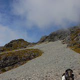
Day 5: The track from Blue Lake to the Waiau Pass, initially climbs for about an hour until you are on top of the terminal moraine wall that divides Lake Constance from Blue Lake. From here, there were great views back over Blue Lake and up the valley over Lake Constance towards the pass.


From here, it was a bit of a slog, first up some scree on the side of the valley, necessary to avoid the bluffs which for the side of the lake, and then up and down some crumbly guts and along the tussock slopes to sidle around Lake Constance. The lake level was evidently still quite high --- the track markers on the top of posts which normally run along the lake side were just visible under the surface of the water. Getting along this section involved a mix of sidling along the rocks and tussock at the lake edge and walking in the lake where it was shallow enough to allow it. It stayed hot and sunny the whole time so it wasn't unpleasant at all to splash along the lake.


After lunch at the head of the lake, it was another long hot slog up the scree slope that forms the northern side of the Waiau Pass. We were repaid with excellent views back over Lake Constance and the Mountains on either side of it. At the top of the pass, we ran into some friends who were doing a similar trip, but in the opposite direction. They had camped at Caroline Creek Biv, in the upper reaches of the Waiau Valley the previous night and were heading on to Blue Lake --- a long day.


The descent from the Waiau Pass wound its way down between numerous bluffs. There were plenty of snow poles about, but without them it would have been a long, slow way down picking a route. From the head of the Waiau Valley we left the track and headed up the Valley to Lake Thompson. The way up wasn't too hard, despite being a bit rough underfoot. We stayed on the true right of the stream that flows out of the lake and then skirted around the lake on the side where the stream exits the lake to a perfect camping spot just before the stream. The weather couldn't have been better for camping, not a cloud to be seen and enough of a breeze to keep the air moving --- essential to stop the condensation in our single wall tent. We zipped down the flap at the end of the tent and slept with our heads under the stars.


 |
| 10-12 Nelson Lakes: Day 5 |
Day 6: Another perfect day, or another day with perfect weather. From Lake Thompson it was a short climb to Thompson Saddle, up some of the only snow we encountered during the trip. From the saddle, route descriptions advise you to stay high and sidle to the true left to avoid getting bluffed in lower down. We started sidling, but evidently, not high enough because we soon found ourselves bluffed in. A bit a sketchy down-climbing and pack lowering on some dodgy rock resulted in my pack taking a tumble. My camera, which was inside my pack was never the same again --- in fact it wasn't even in one piece. At least I managed to get a couple of photos of the cirque at the head of the D'Urville valley, on the other side of Thompson saddle, before it fell.


Once we'd retrieved my pack, and climbed back up to the top of the cirque, we could see that what we should have done was to climb a little after the saddle, reaching a sort of bench on the true left and followed that along until it lead us down to the cirque. At least nothing essential was broken...
We sidled around the cirque, staying at roughly constant altitude until we reached the base of D'Urville saddle on the far side. Although the rock was a bit loose, and steep in places, this wasn't too nasty and we were over in the West Matakitaki before lunch.
From D'Urville saddle, the route initially descends loose scree (lots of fun) to a small lake and huge car sized boulders and blocks (not fun at all). From here, the tempting thing to do was to follow the small stream exiting the lake, down to the head of the East Matakitaki river. Luckily, shortly before the lake, we met a couple of trampers heading in the opposite direction. The way down the stream was nasty and far too steep. The nice way down involved sidling along the true right of the valley and slowly descending down the odd scree, loosing altitude slowly and reaching the river just as it starts to flatten out.
It was slow going down the East Matakitaki River. The flow was still high enough to make river travel a bit of a pain, but in many places it was still the easiest way down. Eventually, we settled for walking in the river, occasionally picking up an over-grown sidle track on the true left and crossing the river whenever necessary.
About 2km before East Matakitaki hut we found a pretty little clearing and camping again --- New Year's Eve in a tent!
 |
| 10-12 Nelson Lakes: Day 6 |
Day 7 (&8): As we got close to East Matakitaki hut, a track started to form and the going was pretty quick. The hut would have been nice to stay at too, situated close to the Matakitaki river (apparently the river had come pretty close to flooding the hut during the heavy rain.)

I took a quick picture of the hut on my phone and we carried on down the river, now with a good track to follow. Just below the confluence of the East and West branches of the Matakitaki the track crosses the river on a three wire bridge over a nice gorgey section. It would have made an excellent photo. We arrived at Bob's hut, beside the West Matakitaki river about lunch time, then spent the afternoon longing about and reading in the sun.

The following day the sun was gone and a few spits of rain made it look unpleasant for a trip back to the tops. We had plenty of time (and meals) still remaining so we collected a load of firewood and spent the day warming ourselves in the hut. Around lunchtime we were join by two trampers who'd stayed at East Matakitaki Hut the previous night after travelling up the D'Urville valley and over David Saddle. They'd seen whio (NZ blue ducks) in the river right next to the hut. One of the two trampers had just turned 65 (he told us about the delights of going to a WINZ office to sign up for his pension); the pass they'd come over the previous day was no trivial climb, nor was the boulder-hop/scrub-bash down the river. Maybe there's still hope for me to get another 35 years use of out my (rather dodgy) knees after all!
 |
| 10-12 Nelson Lakes: Day 7 |
Day 9: From Bob's Hut, a marked track led up the true right of the East Matakitaki river for about 3km before petering out. From here it was, again, a mix of river travel (mostly boulder hopping) and travel beside the river when conditions allowed, with one climb over a shoulder and through some bush on the true left of the river to avoid a small waterfall. Once we got higher up the valley, we were able to climb up the tussock slopes on the true left of the river (now just a stream) to the three tarns which give Three Tarn Pass it's name. From the tarns there are three possible saddles, an obvious (and false) one straight ahead, and what looked like two possible looking saddles on the true left. The route guide had said that the three tarns line up to point you at the correct saddle; well, the almost do, they point you at the scree slope closest to the downhill side of the valley which looks like it has a saddle at it's top. The saddle we wanted was about 50m further along from this --- an easy sidle over some loose rocks got us there. (The saddle marked on the topo50 maps and the GPS put us in exactly the right spot).

The wind racing up the far side of the saddle didn't encourage us to hang about. We dropped down to the small tarns on the south side and then descended, keeping away from the true left of the valley where it looked like bluffs made things difficult. The route down from the saddle to Ada Pass Hut, on the St James Walkway, was pretty quick going. We stayed on the true right all the way down, found a decent trail trough the first section of beech forest and only had to bush-bash for the last 50m or so just above the flats of the St James.
 |
| 10-12 Nelson Lakes: Day 9 |
We stayed the night in Ada Pass Hut, and walked out the next day to Lewis Pass, continuing for 6km or so along the road to Maruia Hot Springs. The Pools there might not be the cheapest, but they are probably the nicest hot pools in the country, and the restaurant there made a welcome change from couscous or spud-dust.
Subscribe to:
Posts (Atom)