I'm well overdue to post something from my trip to Stewart Island. In the two months since I was there, I've probably already shown photos from the trip to anyone likely to read this. But for completeness, and since I've been putting off posting other things, on account of wanting to post this first, (this post is back-dated so that I can still add other things at about the correct dates), I'll put up a few photos now.
The plan: About a year ago, N. decided that she wanted to go back to Stewart Island, but, rather than do something like the North-west circuit where we'd been before, she wanted to go to Port Pegasus in the Southern part of the island.
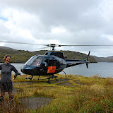
The only information I'd been able to find online, about people visiting Port Pegasus, involved them traveling there by boat and spending most of a day doing so. I didn't know anyone suitable to ask about boat trips but Stewart Island Helicopters sounded like they might be able to help, and I'd never been in a helicopter before.
We arranged to be dropped off by chopper at the old fishing wharf in the north arm of Pegasus, and planned to walk out along the Tin Range to meet up with the South-west Circuit track. We weren't sure exactly what we'd find, or how the tracks would (or would not) be so we allowed 10 days between getting dropped off and when we had to be back in Oban.
Day 1: Helicopter!


From the wharf at North Pegasus we could see across the water to the bay where we suspected that there was an old track that would make the access to the Tin Range tops easier. Just a little around the corner from us, we could hear Pegasus creek and Belltopper Falls where the creek joins the north arm. A short walk had us at the edge of the creek, below the falls, but even without getting a view of the falls it was clear we wouldn't be able to cross.

We decided to continue following Pegasus creek upstream to above where it is joined by a tributary. Despite not having a track to follow, the travel was reasonably easy with not too much undergrowth to slow us down. It wasn't much after four when we reached the tributary above Pegasus creek, but rather than get our feet wet and have to start the next day with damp boots, we took advantage of a nice clearing to put the tent up.


Day 2: When it came time to cross Pegasus Creek it was still looking rather busy, but it was crossable, despite being a bit dicey in a few spots. After crossing the creek, we headed south again towards the water, still with the plan of trying to pick up an old track running from Diprose Bay, up to the Tin range.

By lunchtime, we were back down at the water's edge with a view across to where we had been dropped off about 24 hours previously.

From here we headed north-east, hoping to pick up the old track part way along. Very quickly, the going got slow as the bush started to get thick. We were pushing our way though young rimu and beech with manuka and other scrubby things in between.

We were starting to wonder if we ere ever going to find a track when we stumbled over it. Until then, our average speed had probably been less than a kilometer per hour. This pick up to normal speed once we were on the track and we were hopeful of reaching the tops that night.

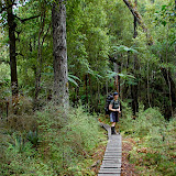
One of the things that is different about traveling off-track in the back-country is not knowing where you will be spending he night. Much of the terrain we'd been through didn't have many places that were clear enough or flat enough to put up a tent, so when we came across a likely looking place in the trees an hour or so before dark we put up the tent and left the last of the climbing for tomorrow morning.

Day 3: A century or so ago, permits were given for tin mining in the Tin range and quite a few mines were dug, though tin was never extracted in commercially viable quantities. The ore was carried down from the tops to Port Pegasus on a wooden tramway and the wooden rails and sleepers are still visible in several places.


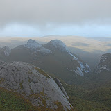
We were now high enough up to get some good views of the Fraser Peaks (Gog and Magog) to the south west of us, and the Deceit Peaks to the north.

We were soon on the tops of the Tin Range. To the North-east of here are the granite domes which are the most distinctive feature of the landscape. They were formed when sedimentary rock lying compressed under the ocean was metamorphised in places by intrusions of magma in particular spots, creating bubbles of granite higher than the granite base. When this rock was lifted up to become Stewart Island, the sedimentary rock was removed by erosion, exposing the granite domes.


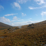
The travel across the tops here was mostly good. There was the odd bit of leatherwood and scrub that we had to contend with, and a few squalls that came through. But in general, we could see where we were heading and could make decent time when we were in the open. There is no marked track across the tops but in several places there was a foot track along the path of least resistance.

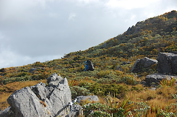


As we got further along we started to notice markers too. Dead leatherwood branches which had been stuck in the ground, or flat stones turned onto their edges, or the occasional small cairn. These markers lead us along the eastern side of Mt Allen, rather than over the top as the maps might have suggested, and past a pretty looking tarn tucked into the side of the hill. Unfortunately, the camping near the tarn all looked a bit damp, so we carried on and followed the markers along a rocky shelf heading slightly north east from Mt Allen towards the Kopeka river. A path through the leatherwood lead down to a nice camp site, complete with fire place and running water where the stream which runs from the saddle between Blaikies Hills and point 731 on Mt Allen, is joined by another stream from the sides of Mt Allen (NZTM E1206621 N4773017 more precisely.)


Day 4: Overnight, the wind picked up quite a lot, bringing a bit of rain and mist with it.

Our plan was to walk from here to the South-west Circuit track and to follow this back to Rakeahua hut. We ended up committed to this plan when a particularly strong gust of wind picked up the tent as we were packing it up. I was holding onto the tent by one of its poles and the tent carried me a couple of metres before I could wrestle it back to the ground. The pole I was holding snapped in the process. It would have been a good idea to pack the tent repair kit I guess.
The weather got worse as we climbed back to the tops. Gust wind was carrying in rain and mist from the North-west making it difficult to pick out the sticks and stones which marked the route.

In a few places we couldn't see more than 10 metres ahead --- not enough to see where we were going. A couple of times we ended up relying on the map and GPS to work out where we should be heading. Inevitably, this meant we ended up traveling the most difficult way through the leatherwood or climbing back up slopes we'd descended without noticing.
We picked up the trail again just before the climb onto Table Hill. Here there a few track markers left from when there was a maintained DoC track connecting Table Hill to the Rakeahua-Doughboy Bay track.

From the Table Hill trig marker we couldn't find any more markers in the clag and headed off in what seemed like a sensible direction, but quickly found ourselves stuck in thick scrub, pushing our way down a steep hillside and crossing streams. A brief gap in the clouds showed some clear ground not far ahead and we headed for this. The skies cleared as we walked out onto some clear land and it wasn't long before we had come across the trail markers again.

Following the trail as it dropped from Table Hill down towards the Rakeahua river gave some nice views of the Ruggedy ranges and the Fiordland mountains. Blundering our way down the hillside in the dusk we disturbed a kiwi out for his evening meal --- the first we had seen on the trip.

Day 5: After arriving at Rakeahua hut, late the previous night we slept in and then washed the mud out of our socks in the Rakeahua river.

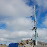
In the afternoon, we made a side-trip up to the top of Mt Rakeahua. The weather was still clear so we had good views back south over Table hill, and north to the Ruggedy range in the west and to Patterson Inlet in the East. After a few days of feeling pretty isolated, it was curious to find a large radio mast and solar panels on the top of Rakeahua.


Day 6: We had now joined up with South-west circuit at about the furthest point from Oban so we had the choice of going back either via Dough Boy and Mason bays, or via Fred's Camp. We'd been to Mason bay before with Romaric so we headed East towards Fred's Camp.

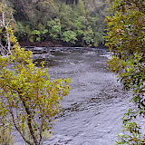
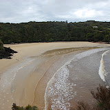
The track initially followed the Rakeahua river. In plenty of places the track was below the height of the river and was accordingly wet. After a couple hours the river met the Southwest arm of Patterson Inlet and the track sidled the bush slopes above the inlet. Every so often the tack would drop down to a beach. One beach had particularly large clusters of black mussels so we collected some for dinner.

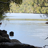
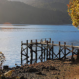
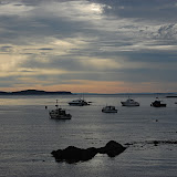
Fred's Camp Hut is set above a small beach on Patterson Inlet, opposite the abandoned settlement of Silvertown.

We cooked up our mussels and then watched the full moon rise over the Inlet.


Day 7: It was another perfect sunny day when we woke up. We could hear kakas squawking in the trees behind us.


The first half of the track from Fred's camp to Freshwater hut is through rimu and miro, climbing over small shoulders at it heads north towards the Freshwater river. After lunch we were visited by a friendly fantail who followed us for almost half an hour, eating the bugs we stirred up. He would stop next to us, close enough to touch and then fly off again before I was able to focus the camera on him.


Once the track reached the valley of the Freshwater river the forest turned to clumps of manuka and areas of open swamp divided by sandbanks. Some of the swampy patches were quite deep --- and not always the ones that looked it. Nicola stuck her pole into a shallow looking patch just before stepping in to it, only to have her pole sink in its full length.


Freshwater hut sits at the junction of the North-west and South-west circuits so we weren't too surprised to have to share it with two other couples. It was good to see a couple of familiar names in the hut book too.
Day 8: Another late start, but this time because the two other couples we'd been sharing the hut with buggered off without bothering to clean the place up. Really! Who else do they think is going to do it? It's nice meeting people from other countries in the backcountry but I think I'm starting to notice a trend with people visiting NZ for a holiday not having a sense of hut etiquette. It's not that difficult really: leave the place like you found it or how you would have liked to find it --- the better of the two. And if you use the firewood, make sure you at least replace what you used. Anyway, enough of that! We zipped along and made it to North arm hut about mid-afternoon. Rather than spend the night there an have a short day the next day we decided to carry on back to Oban and hope to get a room there. From here on the track is part of the Rakiura great walk. It was surprisingly hard to go fast on the track despite huge amounts of board-walk. I blame the wet planks and a heavy pack (still about 15kg).

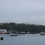
We got to Oban just before six and got one of the last rooms at the hotel above the pub. We were back a couple of days earlier than we had planned, but this was probably for the best since we were arriving just before Easter. Over the next couple of days plenty of people turned up on the island only to have their holiday plans ruined because they couldn't get any accommodation --- including a bogan couple on their honeymoon.
Oban is a pretty nice place to kill a few days; there are plenty of short walks starting around the town and lots of pretty little beaches. Still, by the time we left the island we'd pretty much exhausted all possibilities of entertaining ourselves right down to the magazine selection at the local shop.


For some reason, I thought it would be fun to spend a day in Bluff on the way back to Invercargill and the airport. Don't make the same mistake I did --- stay out of the place unless you have a really good reason to be there. I don't think I've ever been in such an empty town. There were plenty of houses, just nothing else: no shops, no cafes, no nothing. It didn't help that we were there on Easter Sunday, but really, Bluff makes Oban and it's population of 420 look like a bustling city. A novelty road sign will only do so much...

And then it was Invercargill and a plane back to Wellington. I'm already thinking about possibilities for another trip back to Stewart island.
More photos from the various days:

There's also a crappy copy of the GPS tracks superimposed on a topo map of the island. I'll put a zip file with the GPS tracks in Garmin gpx format here for the moment. I might not leave them there but if you want to get hold of them and they've gone, leave me a comment and I can e-mail them.
Nice trip, but I think you had way too much nice weather! ;o)
ReplyDeleteYeah, apart from the one day with bad wind and clouds when we on top of Table Hill, we had unusually good weather. The night we reached Oban though, there was 180mm of rain at the south of the island and some houses on the Muttonbird Island off the south coast fell into the sea in a mudslide. From the pub, we didn't even notice it!
ReplyDeleteyou were in Bluff for half a day - I was there for 18 years - scarred for life - but still the best town ever to be brought up in - there is nothing else to do but get into trouble - and there is nothing to do because it got wrecked because it was something to do - but the people make Bluff what it is - the friendliest you will find anywhere! Great blog by the way
ReplyDelete